Democratic Republic of the Congo–Republic of the Congo border
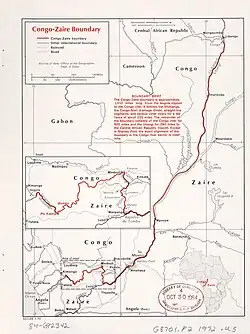
The Democratic Republic of the Congo–Republic of the Congo border is 1,775 kilometres (1,103 mi) in length and runs from the tripoint with Angola in the south to the tripoint with the Central African Republic in the north.[1]
Description
The border starts in the south at the tripoint with the Angolan exclave Cabinda, and loosely follows several rivers including the Chiloango River. It then follows the Congo River, before reaching the confluence with the Ubangi River, one of its tributaries. Much of this segment of the border is poorly defined, and has been the subject of territorial disputes. The remainder of the border follows the Ubangi up to the tripoint with the Central African Republic.[2]
Settlements near the border
 Democratic Republic of the Congo

See also
References
- ^ "Congo, Democratic Republic of the", The World Factbook, Central Intelligence Agency, 2025-10-01, retrieved 2025-10-03
- ^ "International Boundary Study No. 127 – September 8, 1972 Republic of the Congo (Congo) – Democratic Republic of the Congo (Zaire)" (PDF). Office of the Geographer, Bureau of Intelligence and Research.