Flood of 1940 in France
| Date | 16–20 October 1940 |
|---|---|
| Location | Pyrénées-Orientales; Aude; Catalonia |
| Cause | Mediterranean episode (extreme rainfall) |
The Flood of 1940 (in French and Catalan "aiguat de 1940") was a Mediterranean episode of extreme rainfall in October 1940 over the uplands of the eastern Pyrenees. It caused devastating floods in the French departments of Pyrénées-Orientales and Aude as well as in Catalonia in Spain.
Etymology
The Catalan word aiguat (pronounced roughly “eye-goo-at”) has been adopted into French usage to refer to this type of event.
« Quan arriba l'aiguat, hi ha pas res de salvat » (When the aiguat arrives, nothing is saved.)[1]
Overview
The rainy episode in Pyrénées-Orientales lasted from 16 to 20 October 1940. Despite the disruption of meteorological services during the war, 840 mm (33 in) of rain was recorded on 17 October, which is officially considered a European record for 24-hour precipitation; the rain gauge overflowed several times, and a value of 1,000 mm (39 in) is considered consistent with reality.[2] Guillaume Julia, a primary school teacher in Saint-Laurent-de-Cerdans, measured 1,930 mm (76 in) over five days, including 1,000 mm (39 in) on 17 October alone.
The death toll was about 50 in Pyrénées-Orientales (mainly in the Tech valley, around Amélie-les-Bains) and more than 300 in Catalonia. The event led to the evacuation and subsequent closure of the internment camp of Saint-Cyprien. The foreigners interned there at the time (mainly Jews from Central Europe and Nazi Germany) were transferred to Gurs.
Consequences
Consequences in the Tech valley
Effects in Prats-de-Mollo

Prats-de-Mollo-la-Preste lost several of its fountains. The aiguat devastated part of Prats and its valley, notably sweeping away the Pont d'Espagne and several facilities. The disaster contributed to a reorientation of the local economy towards tourism and thermal spa activity.[3][4][5]
Effects in Le Tech
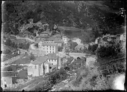
The village of Le Tech was similarly affected. The Notre-Dame-de-l'Assomption church was swept away by the current, leading to its reconstruction on higher ground within the village.[6]
Effects in Arles-sur-Tech
In Arles-sur-Tech, the first factory had been destroyed in a fire in 1927.</ref> factory of the Cémoi group was destroyed by the floodwaters, prompting the company to relocate to Perpignan.[7] A peak discharge of 4,600 m3/s (160,000 cu ft/s) was recorded in the commune.[8] Arles-sur-Tech produced a digital document illustrating the event with period photographs.[9]
Effects in Amélie-les-Bains
Amélie-les-Bains was left in ruins; its railway station (Gare d'Amélie-les-Bains) and casino were swept away as far as Brouilla. Amélie-les-Bains lost 23 residents, nearly half of the French death toll.[10][11]
Other impacts
At Boulou, a peak discharge of 3,500 m3/s (120,000 cu ft/s) was recorded.[8] The Saint-Cyprien camp was destroyed, leading to its closure and the evacuation of its prisoners—particularly towards the Gurs camp and Argelès-sur-Mer (less affected by flooding). Two victims were recorded there, two Spanish women.[12] The railway bridge over the Tech between Elne and Palau-del-Vidre was destroyed, as was the former Can Bia bridge.
Consequences in the Têt valley
Effects in Vernet-les-Bains
The town of Vernet-les-Bains was also impacted: at least 71 houses and five hotels were destroyed by the flood. By 17 October, 58 buildings had already been annihilated. The town's thermal establishment was inundated; the Hôtel du Parc and several villas were swept away. Only the Casino de Vernet-les-Bains and the Hôtel du Portugal remained as witnesses of the town's former spa era.[13][14]
Other impacts
The Basse river flooded with a discharge of 3,600 m3/s (130,000 cu ft/s), as did the Têt, far above its usual discharge of about 11 m3/s (390 cu ft/s). At the Joffre bridge, the water level rose from about 1 m (3.3 ft) to 5.6 m (18 ft).[15]
References
- ^ Soutadé 1993, p. 164
- ^ "Aïguat fantastique sur le Roussillon". Pluies extrêmes (in French). Météo-France.
- ^ "Le chemin des fontaines". Prats ToujOurs (in French).
- ^ "Histoire | Mairie de Prats de Mollo – La Preste" (in French).
- ^ Bonnet-Carbonell, Jocelyne; Carbonell, Charles-Olivier (2007). Prats-de-Mollo et les Pratéens : mémoire de pierres et souvenirs d'hommes. Etnologia (in French). Trabucaire. p. 208. ISBN 978-2-84974-055-2.
- ^ "Le patrimoine Religieux – le-tech-village.fr". le-tech-village.fr (in French).
- ^ Vilallongue. "La Chocolaterie Cantaloup Catala – Mairie d'Arles Sur Tech". ville-arles-sur-tech.fr (in French).
- ^ a b "Plan de préventions des risques naturels" (PDF). pyrenees-orientales.gouv.fr (in French).
- ^ Vilallongue. "L'Aiguat de 1940" (PDF). ville-arles-sur-tech.fr (in French).
- ^ "Ligne d'Elne à Arles sur Tech". chemins.de.traverses.free.fr (in French). Retrieved 13 November 2024.
- ^ "L'Aiguat d'octobre 1940 à Amélie les Bains, la vallée du Tech dévisagée". Amélie les bains (in French). Retrieved 13 November 2024.
- ^ "L'aiguat". memorial-argeles.eu (in French). Retrieved 13 November 2024.
- ^ "Crues catastrophiques et inondations en Conflent : l'aïguat peut-il se reproduire un jour ?". lindependant.fr (in French). Retrieved 13 November 2024.
- ^ "Casino de Vernet les Bains". pop.culture.gouv.fr (in French). Retrieved 13 November 2024.
- ^ "Un territoire marqué par les crues" (PDF). bassintet.fr (in French). Retrieved 13 November 2024.
See also
Bibliography
- Soutadé, Gérard (1993). Les inondations d'octobre 1940 dans les Pyrénées-Orientales (in French). Perpignan: Conseil général, Direction des archives départementales. p. 351. ISBN 978-2-86066-025-9. LCCN 94166617.
- Maurette, Michel (2007). La Crue (in French). Preface by Joseph Ribas. Marcevol: Publications de l'Olivier.
- Jacob, Nicolas (1997). "La crue d'octobre 1940 dans la basse vallée du Tech (Roussillon), d'après les dossiers des sinistrés". Annales de Géographie (in French). 106 (596): 414–424.
- Pardé, Maurice (1941). "La crue fantastique d'octobre 1940 dans le Roussillon". Revue de géographie alpine (in French). 29 (2): 353–357. doi:10.3406/rga.1941.4312.
- Vivian, Huguette (1994). "G. Soutadé : Les inondations d'octobre 1940 dans les Pyrénées Orientales". Revue de géographie alpine (in French). 82 (2): 159–160.
- L'aiguat de 40. Les inondations catastrophiques et les politiques de prévention en Méditerranée nord-occidentale. Actes du congrès de Vernet-les-Bains : les inondations d'octobre 1940 en Catalogne : 50 ans passés, 18–20 octobre 1990 (in Catalan). Barcelona: Generalitat de Catalunya. 1993. p. 484.
- "Aïguat fantastique sur le Roussillon". Pluies extrêmes (in French). Météo-France. Retrieved 9 November 2018.
- Julia, Guillaume. "École de St Laurent de Cerdans, Inondations des 17-18-19 Octobre 1940" (PDF). Pluies extrêmes (in French). Météo-France.