Potonggang-guyok
Potonggang-guyok | |
|---|---|
Guyŏk of Pyongyang | |
| Korean transcription(s) | |
| • Hangul | 보통강구역 |
| • Hanja | 普通江區域 |
| • Revised Romanization | Botonggang-guyeok |
| • McCune–Reischauer | Pot'onggang-guyŏk |
 | |
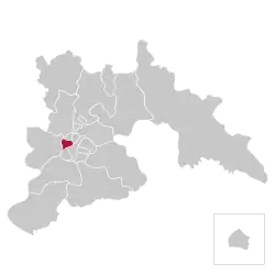 Location of Potonggang-guyok within Pyongyang | |
| Country | North Korea |
| Direct-administered city | P'yŏngyang-Chikhalsi |
| Administrative divisions | 15 administrative dong |
| Area | |
• Total | 7.3 km2 (2.8 sq mi) |
| Population (2008)[1] | |
• Total | 105,180 |
| • Density | 14,000/km2 (37,000/sq mi) |
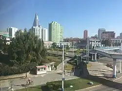
Potonggang-guyok is one of the 18 districts, or guyok, and an artficial island of Pyongyang, North Korea. It is best known as the location of the Ryugyong Hotel. It takes its name from the Pothong River (literally "the simple river"), which forms the district's boundary. Potonggang is bordered to the north by Hyongjesan-guyok, to the east by Sosong and Moranbong, to the south by Pyongchon and Chung, and to the west by Mangyongdae-guyok. The district was established by the Pyongyang City People's Committee in October 1960.
Overview
The Pot'ong District is bounded by the Pothong River and the Pothonggang Canal. Primarily a working district, most sites of interest to visitors lie on the district's periphery. The attractions open to visitors include the Potong River Pleasure Ground, the Victorious Liberation of the Fatherland Statue, and the Potong River Improvement Project Monument. The district is also home to the Pyongyang Embroidery School and Factory and the Pyongyang Senior Middle School. Ragwon-dong houses the central offices and headquarters of the DPRK's National Defense Commission.
The Pyongyang Metro runs through the district, with stations at Konsol, Hwanggumbol, and Konguk.[2]
Administrative divisions
Potonggang-guyok is divided into fifteen administrative districts known as dong (neighborhoods):[3]
| Chosŏn'gŭl | Hancha | |
|---|---|---|
| Kyŏnghŭng-dong | 경흥동 | 慶興洞 |
| Ponghwa-dong | 봉화동 | 烽火洞 |
| Pot'onggang 1-dong | 보통강1동 | 普通江1洞 |
| Pot'onggang 2-dong | 보통강2동 | 普通江2洞 |
| Pulgŭnkori 1-dong | 붉은거리1동 | 붉은거리1洞 |
| Pulgŭnkori 2-dong | 붉은거리2동 | 붉은거리2洞 |
| Pulgŭnkori 3-dong | 붉은거리3동 | 붉은거리3洞 |
| Rakwŏn-dong | 락원동 | 樂園洞 |
| Ryugyŏng 1-dong | 류경1동 | 柳京1洞 |
| Ryugyŏng 2-dong | 류경2동 | 柳京2洞 |
| Segŏri-dong | 세거리동 | 세거리洞 |
| Sŏjang-dong | 서장동 | 西將洞 |
| Sŏk'am-dong | 석암동 | 石岩洞 |
| Sinwŏn-dong | 신원동 | 新院洞 |
| Taebo-dong | 대보동 | 大寶洞 |
References

- ^ North Korea: Administrative Division
- ^ "The Pyongyang Metro: Maps". Archived from the original on 2017-10-26. Retrieved 2013-03-17.
- ^ "더 북한".
