Sagrado Corazón / Monteflores (Santurce)
Sagrado Corazón / Monteflores | |
|---|---|
 Orange house at intersection of Calle Jordan and Ave Manuel Fernandez Juncos in Sagrado Corazon | |
.png) | |
.png) | |
| Commonwealth |  Puerto Rico Puerto Rico |
| Municipality |  San Juan San Juan |
| Barrio | Santurce |
| Population | |
• Total | 3,303 (combined) |
| Source: 2000 United States census | |
Sagrado Corazón and Monteflores are two contiguous neighborhoods with similar characteristics formerly known as the Alto de Ubarri and part of Santurce's 40 subbarrios. Sagrado Corazón measures 0.34 km2 (345,472 m2), with a resident population of 1,646 while Monteflores measures 0.17 km2 (172,397 m2), with a resident population of 1,657, both as of the 2000 United States census.[1]
History
This area was urbanized in the first decades of the 20th century with residences that belonged to the privileged families of the time and is varied in architectural styles. The architect Antonín Nechodoma located his residence in Monteflores and some residences designed by him are still in the area.
In 1940, Monteflores and Sagrado Corazón had a population of 1,229 and 1,638, respectively.[2]
Description
Sagrado Corazón and Monteflores are situated on the highest of Santurces' 5 hills, Monteflores, which reaches a height of 23 meters (75 feet), its borders are Borinquen Avenue to the south, Ponce of León Avenue and San Jorge Street to the west, Tapia Street to the east and to the north San Mateo Street and Eduardo Conde Avenue (Old Seboruco Road) bordering the Villa Palmeras subbarrio.
French-style neoclassic architectural characteristics of the University of the Sacred Heart (Universidad del Sagrado Corazón) where the residence of Pablo Ubarri, Count of Santurce, was located also abound along with Puerto Rican adaptations of Victorian architecture, there are also homes in the "tropical" U.S. influenced Mission Revival, French-gothic, Spanish Colonial Revival, Prairie School, and several apartment structures of the "Art Deco" periods in Bouret street.[3] The Sagrado Corazón neighborhood was added to the Puerto Rico Register of Historic Sites and Zones in 2016 for its architectural value.[4]
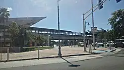
Nowadays, modern high rise apartment buildings dot the area. Sagrado Corazón station is the starting point of the "Tren Urbano" (Urban Train). Various bus lines (guaguas) operate in the area as well.
Gallery
-
 Tren Urbano station in Sagrado Corazon
See also
References
- ^ Puerto Rico 2000: Population and Housing Unit Counts
- ^ "Table 4-Area and Population of Municipalities Urban and Rural: 1930 to 1950" (PDF). United States Census Bureau. Archived (PDF) from the original on August 30, 2015. Retrieved October 30, 2025.
- ^ (in Spanish) Cangrejos - Santurce - Authors; Aníbal Sepúlveda, Jorge Carbonell, Centro de Investigaciones CARIMAR, Oficina Estatal de Preservación Histórica, (1988) (Spanish)
- ^ GOBIERNO DE PUERTO RICO, JUNTA DE PLANIFICACIÓN DE PUERTO RICO (December 7, 2022). "REGISTRO DE PROPIEDADES DESIGNADAS POR LA JUNTA DE PLANIFICACIÓN DE PUERTO RICO" (PDF). jp.pr.gov.
Bibliography
- Puerto Rican Houses in Sociohistorical Perspective Author; Carol F. Jopling - (1988)The University of Tennessee, Knoxville. ISBN 0-87049-543-7 / ISBN 0-87049-763-4
External links
 Media related to Sagrado Corazón (Santurce) at Wikimedia Commons
18°26′31″N 66°03′34″W / 18.44194°N 66.05944°W 18°26′23″N 66°03′23″W / 18.43972°N 66.05639°W