Tornado outbreak and derecho of June 19–22, 2025
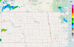 Radar loop of the derecho as it passed over North Dakota, Minnesota and other states and Ontario, Canada on June 20 through the night of June 21. | |
| Meteorological history | |
|---|---|
| Duration | June 19–22, 2025 |
| Tornado outbreak | |
| Tornadoes | 40 |
| Maximum rating | EF5 tornado |
| Highest winds | Tornadic – >210 mph (340 km/h) (Enderlin, North Dakota EF5 on June 20) |
| Largest hail | 4 in (10 cm) near the Jamestown Dam on June 20th[1] |
| Derecho | |
| Highest gusts | 120 mph (190 km/h) (Beltrami County, Minnesota)[2] |
| Maximum rainfall | 6.5 in (170 mm) (Chenango County, New York)[3] |
| Overall effects | |
| Fatalities | 7 (6 tornadic, 1 from downburst) |
| Injuries | >4 |
| Damage | $875 million (2025 USD) |
| Areas affected | Northern United States (Great Plains), Southern Canada, Northeastern United States |
Part of the tornado outbreaks of 2025 | |
A significant tornado outbreak and long-lived derecho affected large portions of the northern United States and southern Canada from June 19–22, 2025, producing widespread destructive winds, numerous tornadoes, large hail, and flash flooding. The multi-day severe weather event impacted the Great Plains, Upper Midwest, and parts of the Northeastern United States, while also producing multiple tornadoes in the Canadian province of Saskatchewan. On June 20, a violent tornado struck rural areas east of Enderlin, North Dakota, resulting in multiple fatalities and catastrophic damage.[4][5] The tornado was later rated EF5 on October 6th, 2025 following a post-event damage survey, marking the first EF5-rated tornado in over 12 years.[6] Additional tornadoes occurred across North Dakota the same day, while a powerful derecho produced hurricane-force straight-line winds across Montana, Minnesota, and the Dakotas.[7] The highest confirmed wind gust during the event reached 120 mph (190 km/h) in Minnesota, causing extensive damage to infrastructure, agriculture, and power networks.[2]
As the storm system continued eastward, it evolved into an intense squall line that affected southern Ontario on June 21. Widespread damaging winds, downbursts, and flash flooding were reported, with one fatality attributed to a downburst.[8] The system then moved into the Northeastern United States early on June 22, generating additional severe weather, including an EF1 tornado in Clark Mills, New York, which killed three people.[4][9]
In total, the outbreak produced approximately 40 confirmed tornadoes across the United States and Canada and resulted in seven fatalities. Damage estimates reached approximately $875 million (USD), largely due to widespread wind damage from the derecho and associated convective systems.[10]
Meteorological synopsis
June 19
The Storm Prediction Center (SPC) had been monitoring favorable conditions for storm development in the Northern Plains/Upper Midwest region since June 18, noting limited low-level moisture and instability with modest wind shear yet steep lapse rates allowing for the development of weak thunderstorms in the area, which could in turn create a threat for isolated wind gusts and large hail.[11] Although an upper-level ridge was present throughout this region on June 19, a weak mid-level shortwave trough moved over the Canadian Prairies which, in combination with a strengthening low-level jet and the advection of warm, moist air, allowed for robust thunderstorm development with the primary threat being large hail and isolated strong wind gusts.[12]
June 20
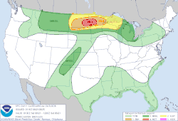

On June 15, the Storm Prediction Center (SPC) noted on its Day 6 outlook that a shortwave, mid-level ridge was forecasted to traverse into the upper Mississippi River valley and remain over the region as mid-level heights increase. Beneath the ridge, a moist and unstable airmass was expected to be in place from the lower to mid-Missouri Valley, northeastward into the western Great Lakes region. Instability and deep-layer shear were sufficient for a localized severe threat, though uncertainties remained on where the greatest potential for convection would be.[14]
A seasonally strong mid-level trough was forecast to eject over the Northern Plains on June 20, which featured moderate upper-level divergence to promote lift and shear support.[14] The Storm Prediction Center (SPC) Day 2 outlook mentioned that "a small area of uncapped and very unstable air mass, perhaps over northeast SD and southeast ND. Here, a conditional supercell and tornado risk will exist ... very large hail and tornadoes appear likely."[15]
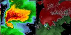
Supercells began developing across eastern North Dakota, around the Jamestown area, in the evening hours of June 20. Although they were initially elevated, the strengthening low-level jet and isentropic/geostrophic ascent contributed to eroding the convective inhibition that was in place, allowing them to become more surface-based.[16] Additionally, a nearby frontal boundary provided extreme storm-relative helicity which further supported surface-based shear and streamwise vorticity as well as development of rotation or mesocyclogenesis within the supercells.[16]
Confirmed tornadoes
| EFU | EF0 | EF1 | EF2 | EF3 | EF4 | EF5 | Total |
|---|---|---|---|---|---|---|---|
| 5 | 14 | 13 | 6 | 1 | 0 | 1 | 40 |
June 19 event
| EF# | Location | County / parish | State / Province | Start coord. | Time (UTC) | Path length | Max. width |
|---|---|---|---|---|---|---|---|
| EF0 | S of Hirsch | Coalfields | SK | 49°08′N 102°35′W / 49.14°N 102.59°W | 22:23 | Unknown | Unknown |
| A brief tornado was recorded, causing no reported damage.[17][18] | |||||||
| EF0 | S of Frobisher (1st tornado) | Coalfields | SK | 49°08′11″N 102°27′09″W / 49.1364°N 102.4524°W | 22:40 | Unknown | Unknown |
| A weak tornado caused minor tree damage.[17][18] | |||||||
| EF2 | S of Frobisher (2nd tornado) | Coalfields | SK | 49°07′57″N 102°25′04″W / 49.1325°N 102.4179°W | 22:45 | 12.5 km (7.8 mi) | 650 m (710 yd) |
| A strong tornado damaged power poles, oil tanks, grain bins, and trees.[17][18] | |||||||
| EF2 | E of Kronau (1st tornado) | Lajord | SK | 50°19′07″N 104°13′25″W / 50.3185°N 104.2235°W | 23:04 | 9.46 km (5.88 mi) | 680 m (740 yd) |
| This tornado damaged a well-constructed home, many farm vehicles, and vegetation in a rural area.[17][18] | |||||||
| EF0 | E of Kronau (2nd tornado) | Lajord | SK | 50°18′54″N 104°10′12″W / 50.315°N 104.170°W | 23:10 | Unknown | Unknown |
| The same storm produced a second, weaker tornado which damaged vegetation and a grain bin.[17][18] | |||||||
| EF1 | Blackstrap Lake | Dundurn | SK | 51°50′19″N 106°22′45″W / 51.8386°N 106.3793°W | 23:25 | 4.25 km (2.64 mi) | 210 m (230 yd) |
| Two residences near the northeastern shore of the lake were damaged by this tornado.[17][18] | |||||||
| EF0 | S of Vibank | Francis | SK | 50°17′N 103°56′W / 50.28°N 103.94°W | 23:51 | Unknown | Unknown |
| A tornado was recorded, causing no reported damage.[17][18] | |||||||
| EF0 | NE of Young | Morris | SK | 51°48′N 105°38′W / 51.80°N 105.64°W | 00:18 | Unknown | Unknown |
| A tornado was recorded, causing no reported damage.[17][18] | |||||||
| EF1 | SW of Dickinson | Stark | ND | 46°46′N 102°55′W / 46.77°N 102.91°W | 00:22–00:24 | 1.38 mi (2.22 km) | 200 yd (180 m) |
| A tornado caused damage along a short path, partially tearing the roofs off two houses and snapping a large branch from a tree. Additional impacts included downed fencing, ripped siding, and two power poles knocked over near the southern end of the damage track.[19] | |||||||
| EF1 | N of Dysart | Touchwood | SK | 51°08′24″N 104°06′56″W / 51.1400°N 104.1156°W | 02:10 | 5.30 km (3.29 mi) | 220 m (240 yd) |
| A tornado caused damage to trees and a shed, additionally causing minor shingle damage to a roof near South Touchwood.[17][18] | |||||||
| EF1 | S of Hubbard | Ituna Bon Accord | SK | 51°05′46″N 103°26′02″W / 51.0960°N 103.4340°W | 03:00 | 11.3 km (7.0 mi) | 890 m (970 yd) |
| This tornado damaged trees, a rural home and farm buildings, and an RV.[17][18] | |||||||
| EF0 | E of Hillside Colony | Spink | SD | 44°44′N 97°59′W / 44.74°N 97.98°W | 03:50 | 0.01 mi (0.016 km) | 10 yd (9.1 m) |
| A storm chaser spotted a brief, weak tornado. No damage was noted.[20] | |||||||
June 20 event
| EF# | Location | County / parish | State | Start coord. | Time (UTC) | Path length | Max. width |
|---|---|---|---|---|---|---|---|
| EFU | SSW of Spiritwood | Stutsman | ND | 46°53′55″N 98°34′43″W / 46.8987°N 98.5786°W | 01:34–01:38 | 1.14 mi (1.83 km) | 50 yd (46 m) |
| A brief tornado occurred, causing no damage.[21] | |||||||
| EFU | NNW of New Salem | Morton | ND | 46°54′59″N 101°29′25″W / 46.9163°N 101.4902°W | 01:40–01:41 | 0.5 mi (0.80 km) | 50 yd (46 m) |
| This tornado occurred in an open field and impacted no structures.[22] | |||||||
| EF2 | NE of New Salem to SSE of Center | Morton | ND | 46°56′55″N 101°19′29″W / 46.9486°N 101.3247°W | 01:48–01:59 | 5.62 mi (9.04 km) | 200 yd (180 m) |
| This tornado damaged three farmsteads after tracking east-northeast from New Salem. The first farmstead had minimal damage. Two separate farm buildings on the second farm lost their roofs and a grain bin was severely damaged. The third farmstead had a damaged roof to the main house as well as one of the farm buildings. A mile of power poles were broken or leaned over in between the second and third farms. A wind turbine was also snapped and toppled near the bottom of the support pole.[23] | |||||||
| EF3 | E of Spiritwood | Stutsman, Barnes | ND | 46°55′24″N 98°27′31″W / 46.9234°N 98.4587°W | 01:51–02:20 | 10.94 mi (17.61 km) | 990 yd (910 m) |
| See section on this tornado.[24] | |||||||
| EF1 | NW of Dickey | LaMoure | ND | 46°36′21″N 98°33′46″W / 46.6058°N 98.5628°W | 02:05–02:07 | 0.23 mi (0.37 km) | 150 yd (140 m) |
| Two farm buildings were damaged and significant tree damage was noted near the touchdown of the tornado. Two ice fishing houses were also damaged and a grain cart with 120 bushels of corn was tossed end over end.[25] | |||||||
| EF0 | SSW of Sanborn | Barnes | ND | 46°52′51″N 98°16′12″W / 46.8808°N 98.2701°W | 02:05–02:23 | 1.05 mi (1.69 km) | 20 yd (18 m) |
| A photogenic, anticyclonic tornado caused no damage over open land.[26] | |||||||
| EFU | NE of Sanger | McLean | ND | 47°14′57″N 100°55′49″W / 47.2492°N 100.9304°W | 02:26–02:27 | 0.35 mi (0.56 km) | 50 yd (46 m) |
| A brief tornado occurred in an open field causing no known damage.[27] | |||||||
| EF2 | SW of Valley City | Barnes | ND | 46°53′29″N 98°06′07″W / 46.8915°N 98.102°W | 02:29–02:50 | 5.79 mi (9.32 km) | 400 yd (370 m) |
| This strong tornado initially caused tree damage with large broken branches before intensifying near several homes. Two homes sustained minor shingle, roof, and siding damage, while one had a collapsed garage and partial porch roof loss. After crossing a ridge near the Sheyenne River, the tornado caused widespread tree damage and struck up to four more homes south of Valley City. One home suffered the most severe damage, with collapsed exterior top-floor walls, total roof destruction, and the complete collapse of a garage. A nearby carport and shed were also partially collapsed. Another home had roof and siding damage with one exterior wall pushed inward. Additional nearby homes experienced window, siding, and shingle damage. Tree damage continued in the area with numerous fallen branches before the tornado lifted.[28] | |||||||
| EF1 | NE of Tappen to NNW of Medina | Kidder, Stutsman | ND | 46°56′26″N 99°34′04″W / 46.9405°N 99.5678°W | 03:07–03:19 | 12.51 mi (20.13 km) | 200 yd (180 m) |
| A QLCS tornado tracked east-northeast, snapping numerous trees down to the trunk, stripping them of leaves and branches. Power transmission towers were bent and twisted. One farm building sustained roof damage while another was completely destroyed. Several homes experienced shingle, siding, garage, and roof damage with debris scattered across properties and found up to half a mile away. Grain bins were dented and a semi trailer was tipped onto its side.[29] | |||||||
| EFU | W of Fort Ransom | LaMoure | ND | 46°31′30″N 98°06′36″W / 46.525°N 98.11°W | 03:10–03:11 | 0.48 mi (0.77 km) | 50 yd (46 m) |
| A tornado was photographed and posted on social media. No known damage occurred.[30] | |||||||
| EF2 | NW of Fort Ransom | Ransom | ND | 46°32′24″N 98°01′49″W / 46.5399°N 98.0302°W | 03:20–03:29 | 5.2 mi (8.4 km) | 400 yd (370 m) |
| The tornado began by damaging three power poles as it tracked northeast. Around the same time, the tornado picked up multiple pieces of large farm machinery, carrying them for up to a half mile. Turning back northwest, it struck a farmhouse and a grove of trees, causing low-end EF2 damage. As it weakened and roped out, it damaged another power pole northwest of the farmstead before dissipating.[31] | |||||||
| EFU | NNW of Fort Ransom | Ransom | ND | 46°34′26″N 97°56′42″W / 46.574°N 97.945°W | 03:22–03:25 | 0.6 mi (0.97 km) | 50 yd (46 m) |
| A satellite tornado to the Fort Ransom EF2 left notable scarring through a field on high-resolution satellite imagery.[32] | |||||||
| EF0 | SW of Hunter to SW of Grandin | Cass | ND | 47°09′02″N 97°15′37″W / 47.1506°N 97.2602°W | 03:36–03:44 | 8.56 mi (13.78 km) | 100 yd (91 m) |
| Several trees were damaged in shelterbelts and ground scouring was noted.[33] | |||||||
| EF1 | N of Hunter | Cass | ND | 47°11′25″N 97°15′36″W / 47.1904°N 97.2601°W | 03:38–03:44 | 5.82 mi (9.37 km) | 300 yd (270 m) |
| Multiple trees were damaged.[34] | |||||||
| EF1 | ESE of Arthur to E of Gardner | Cass | ND | 47°05′20″N 97°07′22″W / 47.0889°N 97.1229°W | 03:41–03:51 | 12.17 mi (19.59 km) | 800 yd (730 m) |
| Several shelterbelts and bean fields sustained damage and a farmstead lost several grain bins, a shed and a machine shop while the house on the property sustained roof damage.[35] | |||||||
| EF1 | NNE of Bordulac to SW of Grace City | Foster | ND | 47°28′56″N 98°55′16″W / 47.4823°N 98.921°W | 03:44–03:51 | 5.79 mi (9.32 km) | 150 yd (140 m) |
| This tornado touched downand traveled northeast, severely damaging a farmstead at the start of its path. A barn lost its entire upper wooden and sheet-metal section, a silo had its top torn off, and multiple barns lost roofs and doors. The tornado crossed open fields before hitting another farmstead, where many trees were broken and large branches were twisted off, including one driven into a camper. Nearby, power lines were brought down and part of a large shop building housing equipment was torn away before the tornado lifted.[36] | |||||||
| EF5 | E of Enderlin | Ransom, Cass | ND | 46°34′22″N 97°36′11″W / 46.5728°N 97.6031°W | 04:04–04:20 | 12.1 mi (19.5 km) | 1,850 yd (1,690 m) |
| 3 deaths – See article on this tornado.[37] | |||||||
| EF1 | N of Oriska | Barnes | ND | 46°58′43″N 97°51′17″W / 46.9787°N 97.8546°W | 04:17–04:22 | 5.01 mi (8.06 km) | 800 yd (730 m) |
| Two farmsteads sustained damage to several buildings, and ground scouring occurred in fields.[38] | |||||||
| EF2 | NE of Enderlin to WSW of Leonard | Cass, Ransom | ND | 46°40′13″N 97°31′30″W / 46.6703°N 97.5251°W | 04:22–04:34 | 6.82 mi (10.98 km) | 1,351 yd (1,235 m) |
| The same supercell that produced the EF5 tornado cycled and produced a strong tornado that caused extensive tree damage; several trees were snapped or uprooted in the affected area. Additionally, several roofs were partially destroyed. It formed just to the east of the path of the EF5 tornado, although they were not on the ground at the same time.[39] | |||||||
| EF0 | N of Sheldon | Ransom | ND | 46°36′31″N 97°29′24″W / 46.6085°N 97.4899°W | 04:35–04:37 | 0.84 mi (1.35 km) | 20 yd (18 m) |
| A tornado scar was noted through farm fields on high-resolution satellite imagery.[40] | |||||||
| EF1 | NE of Leonard to W of Kindred | Cass | ND | 46°41′36″N 97°10′29″W / 46.6932°N 97.1747°W | 04:44–04:51 | 6.86 mi (11.04 km) | 300 yd (270 m) |
| Some tree damage occurred.[41] | |||||||
| EF0 | NE of Leonard | Cass | ND | 46°41′32″N 97°09′32″W / 46.6923°N 97.1589°W | 04:45–04:46 | 0.68 mi (1.09 km) | 10 yd (9.1 m) |
| This tornado left a scar that was discovered on high-resolution satellite imagery.[42] | |||||||
| EF0 | SW of Davenport | Cass | ND | 46°41′33″N 97°07′44″W / 46.6926°N 97.129°W | 04:46–04:47 | 1.86 mi (2.99 km) | 20 yd (18 m) |
| A tornado left a scar that was noted on high-resolution satellite imagery.[43] | |||||||
| EF0 | WNW of Kindred | Cass | ND | 46°39′54″N 97°03′10″W / 46.6649°N 97.0529°W | 04:50–04:51 | 0.74 mi (1.19 km) | 20 yd (18 m) |
| A scar left by a tornado was found on high-resolution satellite imagery.[44] | |||||||
June 21 event
| EF# | Location | Subdivision | Province | Start coord. | Time (UTC) | Path length | Max. width |
|---|---|---|---|---|---|---|---|
| EF0 | SW of Glenbain | Glen Bain | SK | 49°50′N 107°03′W / 49.83°N 107.05°W | 20:55 | Unknown | Unknown |
| A brief tornado caused no known damage.[45][18] | |||||||
| EF0 | N of Cabri | Riverside | SK | 50°39′N 108°28′W / 50.65°N 108.46°W | 22:15 | Unknown | Unknown |
| A brief tornado caused no known damage.[45][18] | |||||||
June 22 event
| EF# | Location | County / parish | State | Start coord. | Time (UTC) | Path length | Max. width |
|---|---|---|---|---|---|---|---|
| EF1 | Clark Mills to N of Clinton | Oneida | NY | 43°05′34″N 75°22′01″W / 43.0928°N 75.3669°W | 07:58–08:03 | 2.43 mi (3.91 km) | 300 yd (270 m) |
| 3 deaths – See section on this tornado.[46] | |||||||
| EF1 | Lairdsville to Franklin Springs | Oneida | NY | 43°05′23″N 75°26′25″W / 43.0897°N 75.4404°W | 07:59–08:10 | 4.74 mi (7.63 km) | 450 yd (410 m) |
| Another spin-up tornado was spawned by the early morning line of severe thunderstorms and was on the ground simultaneously with the EF1 tornado above. It touched down just south of Westmoreland where tree branches were broken, quickly moving into Lairdsville where roofs were damaged. It continued through more rural areas, causing significant damage to farm silo and outbuildings in addition to snapping or uprooting trees. Continuing southeast, it snapped trees on the western edge of the Hamilton College campus before turning more sharply southeast and dissipating.[47] | |||||||
Spiritwood–Urbana, North Dakota
 Drone view of the tornado in Barnes County. The storm's inflow can be seen feeding into the tornado. | |
| Meteorological history | |
|---|---|
| Formed | June 20, 2025, 8:51 p.m. CDT (UTC–05:00) |
| Dissipated | June 20, 2025, 9:20 p.m. CDT (UTC-05:00) |
| Duration | 29 minutes[48] |
| EF3 tornado | |
| on the Enhanced Fujita scale | |
| Highest winds | 155 mph (249 km/h) |
| Overall effects | |
| Fatalities | 0 |
| Injuries | 0 |
| Damage | Unknown |

At 8:51 p.m. CDT (01:51 UTC), this slow-moving and very intense tornado touched down to the east of a Great River Energy station, located south of Spiritwood in eastern Stutsman County. The tornado was widely documented as a "bowl-shaped" condensation funnel, with numerous suction vortices dancing underneath by dozens of storm chasers, as it first traveled to the northeast along 34th Street SE.[49]
The tornado would then start to fully consolidate and cross over into Barnes County, where it began to intensify drastically and start heading more to the north and east. The parent supercell's rear flank downdraft started to wrap around the circulation at this time, with extreme winds observed in excess of 70 mph (110 km/h), though an estimate at 100 mph (160 km/h) was possible.[50] Along 33rd Street SE, the tornado caused EF0 damage to a home west of the Urbana area. The accompanying rear flank downdraft then fully cloaked the tornado behind a heavy curtain of rain, as it began to approach a farmstead. Along the intersection grid of 97th Avenue SE and 32nd Street SE, the tornado then impacted the entire farm, causing EF2 damage to the residence and EF3 damage to a metal farm building that was completely destroyed. A family was sheltering inside the home's basement bathroom as the tornado struck.[51] Vehicles from the property were hurled or deposited in a south-southeastern direction, at a distance of 0.2–0.25 mi (0.32–0.40 km). The rainwrapped tornado headed due north, parallel to 97th Avenue SE as it destroyed another but older farmhouse built in 1891, and debarked trees at EF3 intensity before weakening and moving to the northwest. The occluding tornado would reenter Stutsman County as a tall and photogenic twister before dissipating at 9:20 p.m. CDT (02:20 UTC).[52][48]
This large tornado was the second, and strongest of a family of tornadoes from a long-lived supercell that tracked from Jamestown to the eastern parts of North Dakota. During its 29-minute lifespan, it traveled along a path of 10.94 mi (17.61 km) and had a maximum width of 990 yd (0.56 mi; 0.91 km).[48]
Enderlin–Sheldon, North Dakota
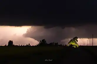 A photo of the tornado near peak intensity, when several train cars were derailed. | |
| Meteorological history | |
|---|---|
| Formed | June 20, 2025, 11:04 p.m. CDT (UTC–05:00) |
| Dissipated | June 20, 2025, 11:20 p.m. CDT (UTC-05:00) |
| Duration | 16 minutes[53] |
| EF5 tornado | |
| on the Enhanced Fujita scale | |
| Highest winds | >210 mph (340 km/h) |
| Overall effects | |
| Fatalities | 3 |
| Injuries | 0 |
| Damage | Unknown |
This large, violent, and deadly tornado touched down at 11:04 p.m. CDT (04:04 UTC) south of Enderlin, initially snapping tree branches at EF0 intensity. The tornado intensified and widened as it moved northeastward across County Road 55 through open fields. The tornado then impacted the ADM Edible Bean Specialties facility at the corner of 136th Avenue SE and County Road 136 at EF2 strength, snapping large trees and destroying an outbuilding.[54]
The tornado then rapidly intensified as it continued northeastward, reaching EF5 intensity as it crossed CPKC's Elbow Lake Subdivision southeast of Enderlin, to northwest of Sheldon, derailing several train cars on a stopped freight train, including one empty tanker car that was thrown 475.5 feet (144.9 m) south of ND 46.[55] Initially, this damage was left unrated, but further analysis determined that there was forensic damage of the lofting of empty tanker cars weighing up to 72,000 pounds (33,000 kg) and tipping over fully loaded grain hopper cars weighing up to 286,000 pounds (130,000 kg) each. Based on this, the rating for this location was upgraded to EF5 with wind speeds greater than 210 mph (340 km/h) on October 6, 2025, the first F5/EF5 tornado to occur in North Dakota since the Fargo tornado exactly 68 years prior.[55] Continuing north, the tornado blew over a cell tower, damaged crop fields, and snapped large trees, debarking some of them. A farmhouse was also swept away, and nearby outbuildings were destroyed. Crossing the highway, two houses were particularly devastated at EF4 intensity, with two fatalities occurring in the area. The first was swept away while the other was leveled.[56] The tornado then began to turn northwest, leveling another home, which caused another fatality, and bending over tall steel electrical transmission towers before weakening and dissipating at 11:20 p.m. UTC (04:20 UTC)[4][53]
Overall, the tornado was on the ground for 16 minutes, had a path length of 12.10 mi (19.47 km), and reached a peak width of 1,850 yd (1.05 mi; 1.69 km). The tornado was the first to be rated EF5 on the Enhanced Fujita scale since the Moore, Oklahoma, tornado on May 20, 2013,[57] and was the first F5/EF5 tornado to occur in North Dakota since the Fargo tornado exactly 68 years prior.[58]
Clark Mills–Clinton, New York
 A tree uprooted by the tornado fell into a house, killing two young girls inside. | |
| Meteorological history | |
|---|---|
| Formed | June 22, 2025, 3:58 a.m. EDT (UTC–04:00) |
| Dissipated | June 22, 2025, 4:03 a.m. EDT (UTC-04:00) |
| Duration | 5 minutes |
| EF1 tornado | |
| on the Enhanced Fujita scale | |
| Highest winds | 105 mph (169 km/h) |
| Overall effects | |
| Fatalities | 3 |
| Injuries | 0 |
| Damage | $440,000 |
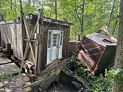
The same line of thunderstorms associated with the earlier derecho continued to move across the Northern United States and Southern Canada, reaching New York by the early morning of June 22.[59] This deadly QLCS tornado formed along a kink in this line, affecting the hamlet of Clark Mills, where three people were killed. The tornado first touched down within Clark Mills and moved southwestward through the hamlet, where it snapped or uprooted many trees.[4][9] In this area, three people were killed when downed trees cut through and crushed their houses. In one house, six-year-old twin girls were killed by a tree that sliced through it, and a 50-year-old woman was killed in another location when a tree fell through the roof and crushed one end of her home; all victims were pronounced dead on the scene.[60][61] Overall, this made the tornado the second-deadliest in New York state history.[62] The tornado then turned sharply to the south, destroying a historic grist mill near Oriskany Creek with nearby heavy machinery being tossed into the creek. Continuing south, it began to move through more rural areas, causing more tree damage before turning southeast and dissipating.[4][9] The tornado became the third deadliest in New York since records began in 1950.[63]
While a tornado warning was issued for south-central Oneida County due to radar-indicated rotation,[64] the tornado initially formed outside of the polygon in an area that was just under a severe thunderstorm warning, although it did have a tornado possible tag. This was due to the warning being for another EF1 tornado that formed around the same time to the west of this one. Additionally, the rotation was assessed as being much farther south than it actually was.[65] This meant that not all of Clark Mills’ residents, including the three victims and their families, received the warning; many residents confirmed that they did not receive any warning. The early-morning time of this tornado also meant that most people were asleep as it touched down, so the warning may not have been able to reach them. It was further clarified that the recent staffing cuts to NOAA and the NWS did not affect the Binghamton office.[66]
Non-tornadic impacts
Derecho
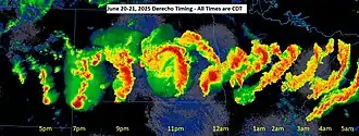
The derecho left over 23,000 people without power in the state of North Dakota.[67] In Bemidji, Minnesota, the derecho blew out windows in a hospital and flipped several vehicles.[67] Wind speeds at the Bemidji airport were recorded at 106 mph (171 km/h).[68]
June 21–22 severe storms
| EF0 | EF1 | EF2 | EF3 | EF4 | EF5 |
|---|---|---|---|---|---|
| 20 | 10 | 1 | 0 | 0 | 0 |
Severe thunderstorms moved into southern Ontario on the evening of June 21 and the early morning of June 22, causing widespread wind damage and several downbursts. The Samuel de Champlain Provincial Park, a popular summer camping spot, was particularly affected by an EF2-rated downburst; hundreds were left stranded due to flash flooding and a particularly strong downburst which downed trees and power lines, blocking off roads, and injured several people.[18][69][70][71] Similar severe weather effects were felt in other areas, such as Algonquin Provincial Park, where two separate downbursts occurred in the area. One of the two caused a tree to fall on a tent, injuring a boy camping with his mother.[72][73][74] Finally, in Mallorytown, Ontario, another downburst uprooted several trees, one of which fell on a tent occupied by a father with his young child; the father was killed while the child survived with serious but non-life-threatening injuries.[18][75] Several municipalities declared states of emergency due to the "devastation" brought by the severe storms.[76] Several downbursts were reported in Quebec on the nighth of June 23.[18] Overall, the downbursts in Canada caused one fatality and at least four injuries.[18]
This same line of storms also pushed into New York on June 22, causing severe wind gusts, some up to 70 mph (110 km/h), which downed trees and power lines. This resulted in blocked roads and loss of power in the region.[9][61] Additionally, rain brought by the storms caused localized flooding.[60][61] Extreme rainfall prompted a rare flash flood emergency for six hours for Chenango County, New York as approximately 6.5 in (170 mm) of rain fell.[60][3] Many people were stranded by flood waters as they flooded creeks, roadways, and homes.[77][59]
See also
- List of derecho events
- Tornadoes of 2025
- Tornado outbreak of June 16–18, 2014 - Another violent tornado outbreak that occurred in the month of June.
- June 2010 Northern Plains tornado outbreak - Another violent tornado outbreak that occurred in the same region.
Notes
References
- ^ "Assessing the damage: A review of the summer solstice severe outbreak". Valley News Live. Retrieved June 29, 2025.
- ^ a b National Weather Service in Grand Forks, North Dakota (June 27, 2025). NWS Damage Survey for Destructive Severe Thunderstorm Near Bemidji Minnesota Overnight June 20 2025 (Report). Iowa Environmental Mesonet. Retrieved June 27, 2025.
- ^ a b NWS Binghamton (June 22, 2025). 24 HOUR PRECIPITATION REPORTS (Report). Iowa Environmental Mesonet. Retrieved June 25, 2025.
- ^ a b c d e Various National Weather Service offices (2025). "Damage Assessment Toolkit" (Interactive map and database). DAT. National Oceanic and Atmospheric Administration.
- ^ "At least 3 dead in North Dakota as severe weather sweeps across region". ABC News. Retrieved June 21, 2025.
- ^ National Weather Service in Grand Forks, North Dakota (October 6, 2025). Enderlin Tornado #1 Upgraded to EF-5 (Report). Iowa Environmental Mesonet. Retrieved February 4, 2026.
- ^ Chada, Meghan (June 23, 2025). "June 20 tornado and derecho recap". KFYR-TV. Retrieved February 4, 2026.
- ^ Tupper, Jon (December 22, 2025). "Canada reels from extreme weather in 2025, from record wildfires to deadly storms". play1037.ca. Retrieved February 4, 2026.
- ^ a b c d National Weather Service in Binghamton, New York (June 22, 2025). NWS Damage Survey Results for Clark Mills Tornado (Report). Iowa Environmental Mesonet. Retrieved June 22, 2025.
- ^ "Natural Catastrophe and Climate Report" (PDF). Gallagher Re. October 2025. Retrieved October 15, 2025.
- ^ "Jun 18, 2025 1300 UTC Day 1 Convective Outlook". SPC. June 18, 2025. Retrieved June 24, 2025.
- ^ "Jun 19, 2025 1300 UTC Day 1 Convective Outlook". June 19, 2025. Retrieved June 24, 2025.
- ^ "Storm Prediction Center Jun 21, 2025 0100 UTC Day 1 Convective Outlook". Storm Prediction Center. June 21, 2025. Retrieved October 7, 2025.
- ^ a b "Mesoscale Analysis Archive". Storm Prediction Center. Retrieved June 22, 2025.
- ^ "Storm Prediction Center Jun 19, 2025 1730 UTC Day 2 Convective Outlook". Storm Prediction Center. Retrieved June 22, 2025.
- ^ a b Moore, Andrew (June 20, 2025). "Storm Prediction Center Mesoscale Discussion 1386". Storm Prediction Center. Retrieved October 8, 2025.
- ^ a b c d e f g h i j Details on June 19 tornado outbreak in SK. Northern Tornadoes Project (Report). July 10, 2025.
- ^ a b c d e f g h i j k l m n o p Northern Tornadoes Project (2025). "NTP Dashboard" (Interactive map and database). westernu.maps.arcis.com.
- ^ National Weather Service in Bismarck, North Dakota (2025). North Dakota Event Report: EF1 Tornado (Report). National Centers for Environmental Information. Retrieved December 9, 2025.
- ^ National Weather Service in Aberdeen, South Dakota (2025). South Dakota Event Report: EF0 Tornado (Report). National Centers for Environmental Information. Retrieved December 9, 2025.
- ^ National Weather Service in Bismarck, North Dakota (2025). North Dakota Event Report: EFU Tornado (Report). National Centers for Environmental Information. Retrieved December 9, 2025.
- ^ National Weather Service in Bismarck, North Dakota (2025). North Dakota Event Report: EFU Tornado (Report). National Centers for Environmental Information. Retrieved December 9, 2025.
- ^ National Weather Service in Bismarck, North Dakota (2025). North Dakota Event Report: EF2 Tornado (Report). National Centers for Environmental Information. Retrieved December 9, 2025.
- ^
- National Weather Service in Bismarck, North Dakota (2025). North Dakota Event Report: EFU Tornado (Report). National Centers for Environmental Information. Retrieved December 9, 2025.
- National Weather Service in Grand Forks, North Dakota (2025). North Dakota Event Report: EF3 Tornado (Report). National Centers for Environmental Information. Retrieved December 9, 2025.
- National Weather Service in Bismarck, North Dakota (2025). North Dakota Event Report: EFU Tornado (Report). National Centers for Environmental Information. Retrieved December 9, 2025.
- ^ National Weather Service in Bismarck, North Dakota (2025). North Dakota Event Report: EF1 Tornado (Report). National Centers for Environmental Information. Retrieved December 9, 2025.
- ^ National Weather Service in Grand Forks, North Dakota (2025). North Dakota Event Report: EF0 Tornado (Report). National Centers for Environmental Information. Retrieved December 9, 2025.
- ^ National Weather Service in Bismarck, North Dakota (2025). North Dakota Event Report: EFU Tornado (Report). National Centers for Environmental Information. Retrieved December 9, 2025.
- ^ National Weather Service in Grand Forks, North Dakota (2025). North Dakota Event Report: EF2 Tornado (Report). National Centers for Environmental Information. Retrieved December 9, 2025.
- ^
- National Weather Service in Bismarck, North Dakota (2025). North Dakota Event Report: EF1 Tornado (Report). National Centers for Environmental Information. Retrieved December 9, 2025.
- National Weather Service in Bismarck, North Dakota (2025). North Dakota Event Report: EF1 Tornado (Report). National Centers for Environmental Information. Retrieved December 9, 2025.
- ^ National Weather Service in Bismarck, North Dakota (2025). North Dakota Event Report: EFU Tornado (Report). National Centers for Environmental Information. Retrieved December 9, 2025.
- ^ National Weather Service in Grand Forks, North Dakota (2025). North Dakota Event Report: EF2 Tornado (Report). National Centers for Environmental Information. Retrieved December 9, 2025.
- ^ National Weather Service in Grand Forks, North Dakota (2025). North Dakota Event Report: EFU Tornado (Report). National Centers for Environmental Information. Retrieved December 9, 2025.
- ^ National Weather Service in Grand Forks, North Dakota (2025). North Dakota Event Report: EF0 Tornado (Report). National Centers for Environmental Information. Retrieved December 9, 2025.
- ^ National Weather Service in Grand Forks, North Dakota (2025). North Dakota Event Report: EF1 Tornado (Report). National Centers for Environmental Information. Retrieved December 9, 2025.
- ^ National Weather Service in Grand Forks, North Dakota (2025). North Dakota Event Report: EF1 Tornado (Report). National Centers for Environmental Information. Retrieved December 9, 2025.
- ^ National Weather Service in Bismarck, North Dakota (2025). North Dakota Event Report: EF1 Tornado (Report). National Centers for Environmental Information. Retrieved December 9, 2025.
- ^
- National Weather Service in Grand Forks, North Dakota (2025). North Dakota Event Report: EF5 Tornado (Report). National Centers for Environmental Information. Retrieved December 9, 2025.
- National Weather Service in Grand Forks, North Dakota (2025). North Dakota Event Report: EF4 Tornado (Report). National Centers for Environmental Information. Retrieved December 9, 2025.
- ^ National Weather Service in Grand Forks, North Dakota (2025). North Dakota Event Report: EF1 Tornado (Report). National Centers for Environmental Information. Retrieved December 9, 2025.
- ^
- National Weather Service in Grand Forks, North Dakota (2025). North Dakota Event Report: EF2 Tornado (Report). National Centers for Environmental Information. Retrieved December 9, 2025.
- National Weather Service in Grand Forks, North Dakota (2025). North Dakota Event Report: EF0 Tornado (Report). National Centers for Environmental Information. Retrieved December 9, 2025.
- ^ National Weather Service in Grand Forks, North Dakota (2025). North Dakota Event Report: EF0 Tornado (Report). National Centers for Environmental Information. Retrieved December 9, 2025.
- ^ National Weather Service in Grand Forks, North Dakota (2025). North Dakota Event Report: EF1 Tornado (Report). National Centers for Environmental Information. Retrieved December 9, 2025.
- ^ National Weather Service in Grand Forks, North Dakota (2025). North Dakota Event Report: EF0 Tornado (Report). National Centers for Environmental Information. Retrieved December 9, 2025.
- ^ National Weather Service in Grand Forks, North Dakota (2025). North Dakota Event Report: EF0 Tornado (Report). National Centers for Environmental Information. Retrieved December 9, 2025.
- ^ National Weather Service in Grand Forks, North Dakota (2025). North Dakota Event Report: EF0 Tornado (Report). National Centers for Environmental Information. Retrieved December 9, 2025.
- ^ a b Three more late-June SK tornadoes. Northern Tornadoes Project (Report). July 11, 2025.
- ^ National Weather Service in Binghamton, New York (2025). New York Event Report: EF1 Tornado (Report). National Centers for Environmental Information. Retrieved December 9, 2025.
- ^ National Weather Service in Binghamton, New York (2025). New York Event Report: EF1 Tornado (Report). National Centers for Environmental Information. Retrieved December 9, 2025.
- ^ a b c The National Oceanic and Atmospheric Administration's finalized damage survey by county
- "North Dakota Event Report: EFU Tornado in Stutsman County". National Centers for Environmental Information. National Weather Service Weather Forecast Office in Bismarck, North Dakota. 2025. Retrieved January 1, 2026.
- "North Dakota Event Report: EF3 Tornado in Barnes County". National Centers for Environmental Information. National Weather Service Weather Forecast Office in Grand Forks, North Dakota. 2025. Retrieved January 1, 2026.
- "North Dakota Event Report: EFU Tornado in Stutsman County". National Centers for Environmental Information. National Weather Service Weather Forecast Office in Bismarck, North Dakota. 2025. Retrieved January 1, 2026.
- ^ National Weather Service WFOs in Bismarck and Grand Forks, North Dakota (2025). "Damage Assessment Toolkit" (Interactive map and database). DAT. National Oceanic and Atmospheric Administration. Retrieved January 1, 2026.
{{cite web}}: CS1 maint: multiple names: authors list (link) CS1 maint: url-status (link) - ^ "2025-06-20 REPORTS: ND/MT/MN". Stormtrack. June 21, 2025. Retrieved January 1, 2026.
- ^ Anhalt, Michael (July 8, 2025). "Spiritwood family thankful to be alive after tornado destroys home". KFYR-TV. Retrieved January 1, 2026.
{{cite news}}: CS1 maint: url-status (link) - ^ National Weather Service WFOs in Bismarck and Grand Forks, North Dakota (2025). "Damage Assessment Toolkit" (Interactive map and database). DAT. National Oceanic and Atmospheric Administration. Retrieved January 1, 2026.
{{cite web}}: CS1 maint: multiple names: authors list (link) CS1 maint: url-status (link) - ^ a b The National Oceanic and Atmospheric Administration's finalized damage survey by county
- "North Dakota Event Report: EF5 Tornado in Ransom County". National Centers for Environmental Information. National Weather Service Weather Forecast Office in Grand Forks, North Dakota. 2025. Retrieved December 15, 2025.
- "North Dakota Event Report: EF4 Tornado in Cass County". National Centers for Environmental Information. National Weather Service Weather Forecast Office in Grand Forks, North Dakota. 2025. Retrieved December 15, 2025.
- ^ Various National Weather Service offices (2025). "Damage Assessment Toolkit" (Interactive map and database). DAT. National Oceanic and Atmospheric Administration.
- ^ a b National Weather Service in Grand Forks, North Dakota (October 6, 2025). Enderlin Tornado #1 Upgraded to EF-5 (Report). Iowa Environmental Mesonet. Retrieved October 6, 2025.
- ^ "At least 3 dead in North Dakota after severe weather swept across region". ABC News. Retrieved June 24, 2025.
- ^ "Nation's first EF5 tornado since 2013 confirmed in North Dakota". KXAN Austin. October 6, 2025. Retrieved December 19, 2025.
- ^ "North Dakota twister becomes first United States EF5 in twelve years". KX News. October 6, 2025. Retrieved December 19, 2025.
- ^ a b Speck, Emilee (June 22, 2025). "6-year-old twins among 3 killed by EF-1 tornado in central New York". FOX Weather. Retrieved June 24, 2025.
- ^ a b c Christopher Mele (June 23, 2025). "3 Dead in Central New York After Tornado Lashes the Area". New York Times. Archived from the original on June 23, 2025. Retrieved June 24, 2025.
- ^ a b c Amy Neff Roth (June 24, 2025). "Cleanup across Mohawk Valley begins after fatal Clark Mills tornado". The Times Telegram. Retrieved June 24, 2025.
- ^ Casey Pritchard; Victoria E. Freile (June 23, 2025). "Deadly tornado sweeps through Oneida County. Fundraiser created for family". Utica Observer Dispatch. Retrieved June 24, 2025.
- ^ "Monthly Climate Reports | National Centers for Environmental Information (NCEI)". www.ncei.noaa.gov. Retrieved February 9, 2026.
- ^ "NWS Binghamton Tornado Warning Number 9". NWS Binghamton. Iowa Environmental Mesonet. June 22, 2025. Retrieved June 25, 2025.
- ^ "BGM SVS #72 2025". Iowa Environmental Mesonet. National Weather Service Binghamton NY. Retrieved June 30, 2025.
- ^ Rachel Polansky (June 25, 2025). "Here's why some people didn't get a tornado warning before deadly EF-1 hit Clark Mills". WSYR. Retrieved June 25, 2025.
- ^ a b "Three Confirmed Dead In North Dakota Derecho". The Weather Channel. June 21, 2025. Retrieved June 25, 2025.
- ^ "Bemidji Blowdown and Other Severe Thunderstorms, June 20-21, 2025". Minnesota Department of Natural Resources. Retrieved June 25, 2025.
- ^ "Emergency crews on scene in Municipality of Calvin and Champlain Park after possible tornado". North Bay Nugget. June 22, 2025. Retrieved June 24, 2025.
- ^ David Briggs (June 23, 2025). "'Longest night of our lives,' enduring Samuel De Champlain weekend storm". Bay Today. Retrieved June 24, 2025.
- ^ "Nearly 300 campers forced to evacuate after storm rips through the northeast". CTV News. June 23, 2025. Retrieved June 24, 2025.
- ^ "Rescuers saw, paddle their way to badly hurt boy in Algonquin Park". CBC. June 23, 2025. Retrieved June 24, 2025.
- ^ Andrew Mendler (June 24, 2025). "'Thunderstorm microburst' causes damage to Algonquin Provincial Park". Muskoka News. Retrieved June 24, 2025.
- ^ Jeff Turl (June 22, 2025). "Hundreds of campers stranded in Algonquin Park by flash floods". Orillia Matters. Retrieved June 24, 2025.
- ^ "Ottawa man camping with child dies after tree falls on tent at Mallorytown campsite". CBC. June 23, 2025. Retrieved June 24, 2025.
- ^ Chris Dawson (June 22, 2025). "Several area municipalities in State of Emergency after major storm". Bay Today. Retrieved June 24, 2025.
- ^ "FLASH FLOOD EMERGENCY FOR CHENANGO COUNTY". NWS Binghamton. June 22, 2025. Retrieved June 25, 2025.
