King's Lynn and West Norfolk
King's Lynn and West Norfolk

| Pays | |
|---|---|
| Nation constitutive | |
| Région | |
| Comté cérémonial | |
| Chef-lieu | |
| Superficie |
1 438,84 km2 () |
| Coordonnées |
52° 45′ 18″ N, 0° 23′ 46″ E |
.svg.png)

| Population |
151 811 hab. () |
|---|---|
| Densité |
105,5 hab./km2 () |
| Statut |
District non métropolitain, borough au Royaume-Uni (depuis le ) |
|---|---|
| Assemblée délibérante |
Council of Borough Council of King's Lynn and West Norfolk (d) |
| Fondation |
|---|
| Site web |
|---|
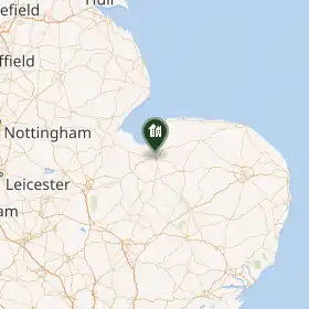
King's Lynn and West Norfolk est un district non métropolitain du Norfolk, en Angleterre. Le conseil de district siège à King's Lynn.
Le district a été créé le par le Local Government Act 1972. Il est issu de la fusion du district municipal de King's Lynn, des districts urbains de Hunstanton et Downham Market, et des districts ruraux de Docking, Downham, Freebridge et Marshland. Originellement appelé West Norfolk, son nom actuel a été adopté en 1981.
Le district comprend l'agglomération de King's Lynn et 102 paroisses environnantes. Lors du recensement de 2001, le district comptait 135 345 habitants pour une superficie de 1 473 km2.
Liste des paroisses civiles
- Anmer
- Bagthorpe with Barmer
- Barton Bendish
- Barwick
- Bawsey
- Bircham
- Boughton
- Brancaster
- Burnham Market
- Burnham Norton
- Burnham Overy
- Burnham Thorpe
- Castle Acre
- Castle Rising
- Choseley
- Clenchwarton
- Congham
- Crimplesham
- Denver
- Dersingham
- Docking
- Downham Market
- Downham West
- East Rudham
- East Walton
- East Winch
- Emneth
- Feltwell
- Fincham
- Flitcham with Appleton
- Fordham
- Fring
- Gayton
- Great Massingham
- Grimston
- Harpley
- Heacham
- Hilgay
- Hillington
- Hockwold cum Wilton
- Holme-next-the-Sea
- Houghton
- Hunstanton
- Ingoldisthorpe
- Leziate
- Little Massingham
- Marham
- Marshland St James
- Methwold
- Middleton
- Nordelph
- North Creake
- North Runcton
- Northwold
- North Wootton
- Old Hunstanton
- Outwell
- Pentney
- Ringstead
- Roydon
- Runcton Holme
- Ryston
- Sandringham
- Sedgeford
- Shernborne
- Shouldham
- Shouldham Thorpe
- Snettisham
- South Creake
- Southery
- South Wootton
- Stanhoe
- Stoke Ferry
- Stow Bardolph
- Stradsett
- Syderstone
- Terrington St Clement
- Terrington St John
- Thornham
- Tilney All Saints
- Tilney St Lawrence
- Titchwell
- Tottenhill
- Upwell
- Walpole
- Walpole Cross Keys
- Walpole Highway
- Walsoken
- Watlington
- Welney
- Wereham
- West Acre
- West Dereham
- West Rudham
- West Walton
- West Winch
- Wiggenhall St Germans
- Wiggenhall St Mary Magdalen
- Wimbotsham
- Wormegay
- Wretton
Source
- (en) Cet article est partiellement ou en totalité issu de l’article de Wikipédia en anglais intitulé « King's Lynn and West Norfolk » (voir la liste des auteurs).
Lien externe
 Portail de l’Angleterre